Helen Moat shares three walks which take in the first section of the Peak District Geo Walk, a long-distance route that showcases the area’s geology
To make the routes circular, I leave the geo trail behind to return the rambler to their starting point.
While the walker may leave the geo route, the Peak District’s striking geology continues to make its presence felt on the return. For more information on the Peak District GeoWalk, visit peakdistrictgeowalk.org.

Matlock to Cromford
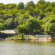
This ramble takes in the initial miles of the Peak District Geo Walk. The 6.7-mile ramble leaves the long-distance route behind at Cromford, circling back to Matlock via High Tor from Matlock Bath. It’s a lovely walk that cuts across the hillside above the dramatic gorge of the Matlock spa towns.
It certainly takes in some dramatic geology, the telltale adits cutting through rockfaces evidence of a lucrative mining industry on Masson Hill and High Tor.
Heading through Matlock’s Hall Leys Park from the town bridge, walk out the other end into Knowleston Place. Turn right into Knowleston Gardens and cross the pedestrian bridge. Turn right again to follow the bank of the River Derwent.
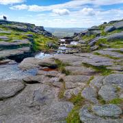
The soaring limestone rock cliffs are your first introduction to the area’s magnificent geology. Look closely and you can find fossilised shells – brachiopods – showing us Matlock once lay under an ocean. Pause to read the information board, telling the story of Ladygate Mine and its unsuccessful attempt to mine galena, a lead ore.
Reaching another pedestrian bridge, traverse it, then cross the A6. Follow the road for a short distance in the direction of Matlock Bath, then climb St John’s Road as far as Primrose Cottages.
Take the path opposite. For all the world it looks like a garden pathway, solar lighting and a wooden doorway adding to the feeling you’re trespassing; it is a public footpath, however.
Reaching steep open land turn left and follow the garden wall to drop down to St John’s Road again. You’ll get your first views of the imposing cliff faces of High Tor on the other side of the gorge.
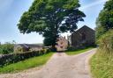
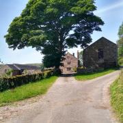
Passing the fairytale-like St John the Baptist Church, continue to the end of the road. At Cliffe House take the path right to follow the wall boundary through woodland and out onto open land, skirting Masson Farm.
Follow the path as it climbs Masson Hill towards the top of Heights of Abraham. The concrete path you meet zigzags up to Tinker’s Shaft, the fantastic viewpoint on the platform taking in Matlock, Starkholmes and High Tor.
Notice the large dolostone boulders scattered around the path. From Tinker’s Shaft, retrace your steps a short way and follow the track marked with public footpath signposts.
The area here on Masson Hill is a Site of Special Scientific Interest, riddled with lead mines that date to Roman times. Barite and fluorite were extracted through the centuries until the 1900s.
Leaving the track behind at the cattlegrid, go through the gate into woodland. It crosses the valley above Matlock Bath. Another gate takes you out onto open land. At the three-way split follow the lefthand path along the field boundary to Upperwood.
Turn left after the trough to follow the Derwent Valley Walk signpost. On meeting a road, follow it downhill and on through pretty cottages. It looks like you’re heading down a driveway, but the track leads to a pathway.
Follow the signpost for Scarthin into woodland. Continue round the wooded hillside, passing the imposing Cromford Court. Veer right, looking for an adit in the rock. Look closely and you’ll spot veins of calcite with the appearance of crystals.
Take a sharp left to drop to Scarthin road in Cromford. Follow it past the duckpond. Scarthin Bookshop offers a welcome break in its upstairs cafe behind its curved bookcase.
Leaving the Geowalk route to make your ramble circular, follow the A6 pavement into Matlock Bath. Cross the pedestrian bridge leading to the cable car and head uphill, turning left to climb to High Tor.
Drop off the hill and through the gate. Turn left to descend to the River Derwent. Turn right to retrace your steps to your starting point.

Cromford to the National Stone Centre
If you are driving (bus fares are great value presently), park considerately on Intake Lane. At the top of the road, Intake Lane becomes a track, the landscape underlain with Bowland shale.
The lane has an otherworldly feel, beeches and stone walls covered in lustrous moss. As you approach the top – just before taking a sharp right to reach the High Peak Trail after the railway tunnel – more sandstone rocks of Ashover Grit make an appearance.
The geology goes beyond the exposed rocks; it has shaped the manmade landscape too. The High Peak Trail was once a railway line, delivering quarried limestone across the Peak. Wagons were hauled up the steep incline by the Sheep Pasture Engine House at the top.
As you emerge from the trees, the landscape opens out with breathtaking views of Cromford, High Tor and Matlock beyond. From here the path is level. Dene Quarry comes into view, another reminder of how man has reshaped the landscape because of the local stone.
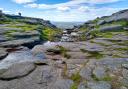
If you have the energy (and mobility) it’s worth detouring to scramble Black Rock with magnificent views. During the Carboniferous Period, this wodge of sandy sediment slid off the front of an unstable river delta into tropical Derbyshire seas.
Reaching the National Stone Centre, you’ll see more evidence this part of the world was under the sea millions of years ago. As you explore, you’ll discover the finest examples of fossil corals, crinoids and brachiopods.
Once more, we see how stone has served man; the geo-path has numerous examples of dry-stone walls. The walls vary in colour and texture, built with local stone.
Drop into the cafe for coffee and cake (or lunch) and find out more about Britain’s geology in the exhibition corner.
From here we leave the Peak District Geo Walk long-distance path, but not the geology!
Heading up to the main road (B5035), turn left onto it, crossing at Sheep Pasture bus stop to follow a track over the stone bridge of the narrow-gauge railway. At its end, turn right to cross into Gang Mine Nature Reserve.
While the focus is on botany here, it’s the geology, the lead-rich soil that feeds the carpets of flowers: wild thyme, sandwort, alpine pennycress, kidney vetch and mountain pansies.
As you drop to the road, ignore the signs and veer left to follow the stone embankment uphill. Go through a gate on the right to follow a narrow path that skirts the top of Dene Quarry.
This massive hole in the hillside is an unpleasant sight, but the stone it extracts and crushes is necessary for building our motorways. When its licence runs out, nature (with a little help) will soften the scarred landscape.
Emerging at the entrance of the quarry site, turn left then right to take the track downhill. It emerges at Cromford Hill. Cross the road and turn right to follow the public signpost through cottages to North Street, where Arkwright created homes and a school for his mill workers.
Continue through Oakhill hotel (afternoon tea on offer) and onto Intake Lane. A right turn takes you back to your starting point after a fascinating almost-five-mile geology-packed ramble.

From Middleton Top to Harboro Rocks
At Middleton Top (parking charge) take time to look at the old engine house with its carriage. As you head along the High Peak Trail in the direction of Harboro Rocks, the mines and gravel works that made use of the railway line remain evident, disused and active.
Dive into Hopton Tunnel, the cut slicing through limestone and dolomite. The tracks of the Cromford and High Peak Railway Line may be gone (operation ceasing in the 1960s), but the railway tunnels and bridges are a testament to the old line, along with the railway cottage you pass.
The trains have been silenced and, in their place, great wind turbines take possession of the sky as you pass Carsington Pasture. Love or hate them, you can’t help but be impressed by their scale.
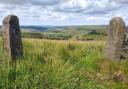
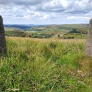
Soon you will reach Harboro Rocks. Turn right opposite Hoben International works and make your way to the summit with its trigpoint.
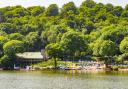
The craggy dolomite outcrops are impressive; even more so the views from the top. Circle round to take in Carsington Water, Riber Castle and Masson Hill.
Drop down the other side of Harboro Rocks through fields to New Harboro Farm, passing the house on your right. Continue down to a wide farm track and turn right on it.
As it drops down to gates accessing gravel and sand workings, turn left over a stile and follow the grassy (sometimes muddy) path down to Hopton Via Gellia.
Cross the road, climbing past Arm Lees Farm and continue over fields to Moor Farm, veering left to pass the derelict buildings. Soon you’ll hit the High Peak Trail again.
Turn left to retrace your steps to Middleton Top. If the little shop is open, (weekends and holidays) treat yourself to a snack and rest on one of the benches with great views of the White Peak – a fitting ending to this just under five-mile walk.
READ MORE: Peak District GeoWalk: Ladybower reservoir and Derwent Edge