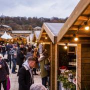
It’s that time of the year where a good walk is always enhanced with an equally good drink at the end of it. Helen runs the rule over four different strolls which end at fabulous beer gardens!

Duffield ramble
Parking at St Alkmund’s church (free), head for the handsome Grade I listed church and war memorial, going through the field to the left of the church.
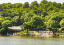
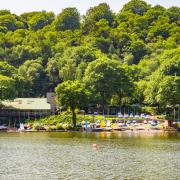
Where the two grassy paths diverge, take the one veering left. It joins the banks of the River Derwent with views over to the Bridge Inn beer garden.
Emerge onto Makeney Road and turn right to cross the bridge, then right again onto Eaton Bank. At the end of the Bridge Inn (resisting its tempting beer garden for the moment), continue along the path signed ‘footpath for Eaton Bank’. It takes you through the idyllic flood meadows of the Derwent, the soaring chimney of Peckwash Mill ahead of you.
A narrow path funnels you through woodland to the private drive of the mill. The pathway veers left to climb parallel to the driveway up to Eaton Bank (road).
Turn right onto the road. At the end of a row of houses on your left, cross the road to follow the green ‘Restricted Byway’ sign uphill along a narrow, surfaced lane.
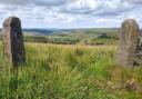
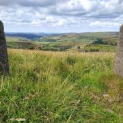
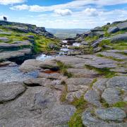
Ignoring all paths on the right, continue straight on uphill past a disused quarry. The lane veers right. At its end, take the path through fields to Park Farm, views opening out to Derby on your right. You’ll also notice a curious modern stone circle.
Go through Park Farm, passing through a gate (signposted Route 9) into a field. At the bottom, turn left to continue along its perimeter, signposted ‘To Holbrook.’ Continue through fields of mature trees (old parkland), climbing to woodland, crossing two simple footbridges along the way.
Go through a gate and turn left to skirt the woodland perimeter, veering left to follow the Centenary Way (also the Midshires Way at this point). A marker on a tree points you in the right direction. From here the route follows field boundaries before dropping steeply down steps to a little lane of terraced cottages.
Turn right at its end onto Eaton Bank. At the bottom, the beer garden of the Bridge Inn welcomes you with a cold pint or chilled wine – the perfect end to a 3.3-mile summer ramble. Relax as the Derwent flows gently past you before retracing your steps to the car park.
Longlane Village walk
On a warm evening when the light stretches well beyond 9pm, you can take a short summer stroll of just 1.4-miles along a country lane and back through fields before treating yourself to a garden meal or drink at the charming Horseshoe Inn.
The pub offers intimate dining pods at the back and yet more comfortable seating on the lawned front, surrounded by trees, topiary and boxed hedges. There’s layby parking opposite the Horseshoe Inn.
Resisting the Horseshoe for the moment, head up Long Lane in the direction of the school and church, taking the first public footpath pointing into a field on your right. Cross the field diagonally towards the gap in the hedge (skirting round the boundary of the school).
Climb over the stile into Osleston Lane and turn right. This quiet country lane of handsome country houses dips down to a stream before rising again. Look out for a public footpath sign on your right.
Climb over the wooden slats and cross into a second field. Head downhill through two more fields, crossing a footbridge hidden in the hedgerow at the bottom.
Continue to the corner of the field, where a stile in the hedgerow takes you into another field. Climb over it and continue along the right-hand boundary of a couple more fields before emerging at Long Lane again.
Turn right and before long the Horseshoe Inn will greet you with its delightful gardens, both front and back.

Mugginton Circular
This 4.5-mile walk through the rolling hills of South Derbyshire is one of pastoral delight, taking the rambler through fields and farms and on through the charming villages of Mugginton and Weston Underwood.
Starting out from the Cock Inn car park (ask for permission first before heading out on your walk), turn right onto Church Lane then immediately left after Woodside Cottage. The gravel track heads into trees where it becomes a dirt track. Head downhill, passing a cottage directly on your right.
Arriving shortly at a second junction of paths, drop down steeply in the direction of the equestrian centre, Old Covert Farm. Go through the wicket gate into a field and continue down towards the farm. Climb up through the other side of the valley, passing the farmyard on your left, then down through fields to another horse farm.
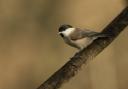
Turn left through the gate, passing stables on your right. The grassy path funnels you downhill between fence and hedgerow and on through fields (with plenty of rabbits and birds of prey along the way). The grassy path rises again, then veers left.
Go through the gate, keeping the hedge boundary on your left. Continuing straight on at a junction of paths, descend downhill before merging with a farm track. Leave this after a short distance to climb over a stile on the right into a field with a pond. Climb the hill towards Mugginton Church. The route continues through the graveyard. Skirt round the side of the church to drop down to Church Lane.
Head up the lane for a short distance, turning right into Malkin Lane (signed public footpath). At the end of the driveway, continue between hedges, then across fields to Weston Underwood, crossing Greenlane Brook footbridge.

Go through the kissing gate onto Green Lane and turn right onto Bullhurst Lane. Just up the road, Inn Farm Dairy offers a wide range of ice-cream flavours from its dispenser (and a well-earned rest).
Cardboard cutouts (and the real ‘McCow’ in the surrounding byres) advertising the fresh milk, milkshakes and ice-creams for sale.
Rested, continue up the hill, turning left into Burland Green Lane. After passing several houses on your left, go through the field gate at the driveway of a split-level house (signed). Follow the left boundary down to a gate and cross over the stream (the footbridge having seen better days) into another field.
Head over the field and through the gate to cross a large sloping field. At its end go through the field boundary to follow the narrow path between Chilla Carr (shrubby land and trees) and farmland.
At the end of Chilla Carr veer right into a large field, continue through two more fields. Ignoring the gate ahead of you in the third field, veer west towards a white farm building (Leasow), crossing a stream before skirting up and round the field boundary to the house.
Continue through the farmyard and on up the farm lane, veering left to continue along Highfield Lane. At its end, turn left onto Muggintonlane End. You’ll see the Cock Inn in front of you. The beautiful beer garden has comfortable seating and dining pods scattered among the box hedges, ornamental trees and shrubs.
Apart from fine views towards Derby from the picnic benches at the back of the car park, the old inn has an interesting history.
It was on the turnpike road between London and Manchester. As well as serving as a toll bar (and respite for weary travellers), it was home to the sturdy cock horses hired by wagon drivers to pull heavy loads up the hill from Weston Underwood in the 18th and 19th centuries.