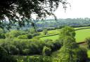
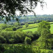
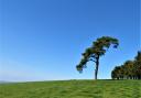
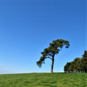
Less than 20 miles long, the River Culm is one of my favourite Devon rivers. It packs a lot into its few miles as it meanders through its valley, bristling with wildlife and history. Although this walk only follows the river for a short distance through Uffculme, we climb to heights that give glorious views across that valley and to the Blackdown Hills. Footpaths are interspersed with stretches of quiet lanes, so you will need to watch for traffic occasionally, and there are plenty of refreshment opportunities before, during and after the walk.
Tranquil paths, panoramic views, beautiful woodland and glimpses of the past – relish it.
THE WALK

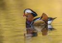
1. Wherever you park on Mill Street, walk to the bottom of the road, where you meet the River Culm. There’s a footbridge to the left, from which I’ve often spotted kingfishers, but the walk turns right, walking away from the bridge, passing Riverside Cottage on your right. Pass through a gateway, the river is over to your left, and this path is the line of the former Culm Valley Light Railway, which closed to passengers in 1963 but still carried milk trains into the Seventies. A few metres after the gateway go through the smaller gate on the left, which gives access up to the riverside path. There is often a host of ducklings here in spring.
Follow the river towards the road bridge, and as you reach it bear right, round the end of garden fences, to emerge onto the road. Turn left, cross the bridge, and at its end take the footpath going right, down steps. Follow the path, river to your right (and the buildings of a feed mill!), walking through a long meadow.

2. The path arrives at a kissing gate with footpath arrows. Beyond the gate turn left, away from the river, and walk through the field with a line of elegant poplars to your left, heading towards a footpath gate 100m away just beyond a couple of oak trees. Go through and bear diagonally right, uphill, towards a cream-coloured house. Pause as you approach the top of the field and glance back. The arresting brick chimney of Coldharbour Mill towers above Uffculme, a still-functioning woollen mill that’s been in continuous production since 1797. At the other side of the village the spire of the parish church stands much shorter than the chimney, and the substantial red-brick edifice of a former brewery also dominates the view.
Go through the gate and turn right along the lane. In 200m turn left at the grassy triangle and stay with the rising lane, ignoring any tracks off. 250m from the triangle ignore a footpath that goes left along a track and keep straight ahead, passing the rather grand Gaddon House on your right. Soon the surfaced lane ends but a narrow path continues – follow it towards Gaddon’s tree-clad hillside ahead.
After a stout climb the path enters the edge of the woodland and swings left.

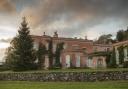
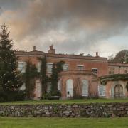
3. Follow this delightful byway around the periphery of the wood. It’s a beautiful place but isn’t access land and there is one of those whiffs of the territorial hereabouts, so stay on the track. Depending on the leafiness of the trees to your left, you will be rewarded for the climb with occasional glimpses of splendid valley views, encompassing the area we’ve just walked. At points the parkland and mansion of Bridwell Court, home to Lord Mountbatten, is also visible to the left of the village.
After 300m the track reaches a three-way fingerpost. Turn left along the signed bridleway, another fine stretch of walking with (again, dependent on the foliage) occasional valley views to the left and Blackdown views to the right. Way, way in the left-hand distance a stand of wind turbines twinkles whitely – these are the ones alongside the North Devon Link Road.

4. The track leads to the lush woodland of Slow Jacks – if anyone knows the origin of the name I’d love to hear it. At a three-way fingerpost turn right on the footpath, passing through a gate and walking alongside an old tree boundary on the right, the smooth-barked beeches towering over the path, which soon reaches a stile.
This leads out into a delicious view. Savour it, then bear diagonally right down the field, passing a lone oak on your right. If your right leg is significantly shorter than your left, this will be a more comfortable descent.
As you near the bottom, a line of tall trees ambles down the hillside to your right, and below them, in the bottom hedge, a stile leads out to the road. Turn right.

5. At the road junction within 100m turn left towards Ashill and Culmstock. Follow the road for almost 300m, then look for the (possibly rather overgrown) footpath fingerpost on the left of the lane that points obliquely right, through a field gateway. Turn right into the field then walk diagonally left across it, aiming for the houses of Ashill.
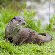
This line brings you to an arrowed gate within 100m. Go through and turn left, walking beside the left-hand boundary. In the field corner go left through the gap then bear right and continue, now with the hedge on your right. In about 70m cross the stile on the right then follow the narrow path beyond. Sometimes there are alpacas around here.
The path widens at a meeting of gates with a two-way fingerpost. Our homeward journey will lie along the footpath to the left, but first it’s worth keeping ahead into Ashill, so go through the metal footpath- farm-gate combo and head along the road into the village, passing the village hall on your right. At the T-junction the Ashill Inn awaits.
I have to commend this place: when we arrived, hot and hungry, they were having a dreadful, smoke-filled-electrics moment, but they still managed to rustle up a couple of emergency pizzas for us, cooked in their garden bar which operates from a different circuit. They were thoroughly delicious.
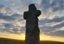
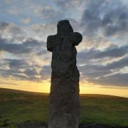
6. Leave the Ashill Inn and retrace your steps past the village hall and back to the two-way fingerpost. Go right, uphill, along the fenced path. High to the right sits Culmstock Beacon. The hut up there is a monument to a communications system which predates emails and mobile phones by several centuries. It once housed a pole which, protruding through the roof, supported a beacon fire, and was one of a series of such beacons used to alert England to the imminence of attack from the Spanish Armada. The hut’s windows face in the direction of the two nearest beacons in the chain so that the beacon-keeper could watch for a neighbour’s signal whilst sheltering in the hut. There is uncertainty about the age of the existing hut, but it’s likely that there has been a beacon on the site since medieval times.
Follow the path in a straight line through a couple of small fields until you reach the lane by the entrance to High View Farm. Turn left along the lane, passing Southwood Farm, and at Reed Cross keep straight ahead for another 380m to Twenty Acres Cross. Here turn left on the lane, uphill, and with 200m you reach a bridleway on the right, take this.

7. We’re now climbing towards the trees of Slow Jacks again – it’s worth visiting it twice from different angles. In spring, these old beech woodlands, traversed by historic boundary banks, are bright overhead with freshly unfurled beech ‘pennies’: newness within oldness. In autumn there are interesting fungi to find.
In just over 250m the track reaches a three-way fingerpost. Go sharp right here, back on yourself, descending beside a treed boundary with more magnificent views to the left. Within 100m veer left down to a tucked away stile, cross this, out of the woodland, and walk down the steep field alongside the right-hand boundary to another stile. The spire of Uffculme Church beckons. Just over 100m beyond the second stile, a gate down on the right leads out to the road – turn left along it.
8. Follow the road for a third-of-a-mile to Cemetery Corner, where you reach a slightly busier road into Uffculme – so please be careful. Cross over and turn left, and after a short way you can make use of the pavement on the right of the road. When you arrive at the road bridge over the Culm, cross it, then turn right, to retrace your steps along the riverside path back to the bottom of Mill Street.
4 things to do while you’re in the area
1: Coldharbour Mill is a working woollen mill and museum which also hosts ‘steam up’ days throughout the year
2: Bridwell Court is surrounded by old parkland which hosts many events throughout the year and is a lovely place just to wander
3: Cullompton Farmers Market takes places on the second and fourth Saturday of each month, selling lots of local produce, including delectable organic veg from Little Bishops
4: Hemyock Castle is a privately owned 14th century castle that opens to the public on certain days of the year
Compass points
Start point: Mill Street, Uffculme. Postcode: EX15 3AT; grid ref: ST071127
Parking: On Mill Street, with consideration for residents
Map: OS Explorer 128 Taunton and Blackdown Hills, 1:25 000 (this scale shows greater detail than the map printed here)
Distance: 5 miles
Terrain: Riverside and field paths, woodland tracks, some roads. Expect mud
Exertion: Moderate
Dog data: Animals grazing; all stiles have gaps beside them; roads
Refreshments: En route: The Ashill Inn, EX15 3NL (01884 840506). In Uffculme Square: The Ostler Inn (01884 840260); No 11 Café (01884 842542). On the edge of Uffculme: Grist Mill Café at Coldharbour (01884 840960); The Orangery at Bridwell (01884 840950)
Public transport: A bus service calls at Uffculme
Simone Stanbrook-Byrne has written a selection of West Country guides including Circular Walks in Central Devon