Stroll some remote sea-walls on the southern edge of the Blackwater Estuary, including some not accessible until recently. The scenery is glorious

The Walk
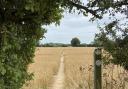
1. From The Star Inn head east, towards Bradwell, along the main road footway; if in doubt, the wide grassed verge with trees should be on the left-hand side of the road. Pass several old cottages on the way out of the village then cross the entrance of Stansgate Road, continuing on the green verge of the main road. At Poplars Farm, just past a layby, turn left off the road along a signposted field-edge footpath. At the top of the field the path follows the edge round to the right, then crosses a footbridge to pass diagonally over the next field. At its far edge turn left, keeping the hedgerow on your right. Ahead to your left is the imposing red-brick farmhouse at Steeplewick Farm.
2. Towards the end of the field, at a waymarker post, the path rises to the crest of an old, now landlocked, sea-wall. Here it swings around to the right before turning left through an old gateway and then crossing a footbridge. The path then descends from the old sea-wall and continues left along the field edge. A sweeping anticlockwise bend leads to a point with a better view of the large (though mainly modern) house. Follow the field-edge track over a ditch.

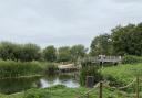
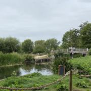
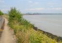
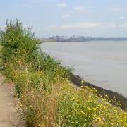
3. In a further 400 metres do not follow the track into another field, instead keep right, with the hedgerow on the left and soon pass through a wooden pedestrian gate beside a metal field gate. To the right is now grassland leading to shallow water inhabited by a variety of wetland birds, including avocets. Stay on the path alongside the hedge and pass through another wooden pedestrian gate to emerge at the sea-wall. Turn left and find a shallow section of the slope to climb to the footpath cresting the bank. It may already be possible to hear the clanking of rigging on masts and soon the Marconi Sailing Club premises come into view. In the distance, to the east, the twin monoliths of the old Bradwell nuclear power station can be seen on a clear day, while upstream across the estuary is Osea Island.
4. Just past the Coastguard Kitchen, with its disproportionately large chimney breast, descend the sea-wall, as indicated by a waymarker at the storm-gates, and head briefly inland along the access road. Squeeze through a tight kissing gate at the entrance then in 150 metres turn off left, through a metal gate beside ‘England Coast Path’ signage. This new public path leads to a section of sea-wall previously not open to the public. At the sea-wall admire the excellent view across to Osea Island before heading left along the path, which soon descends to run between the sea-wall and the adjacent dyke.
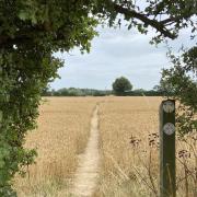
5. In just over a kilometre, waymarkers indicate the path returns to the top of the seawall, where it passes through (or in one case beside) a pair of metal gates. A footpath leads off inland, eventually returning to Steeple, but instead remain on the sea-wall path, enjoying the classic Essex coastal scenery.
6. After a few twists and turns, the path approaches the Steeple Bay Holiday Park which welcomes visitors to use the restaurant, bar, shop, etc. On leaving the Holiday Camp continue along the sea-wall path, alongside Mayland Creek. After a kilometre or so it sweeps left before bending sharp right.
7. 200 metres after the bend take a waymarked path on the left, heading inland. This soon leads, through a wooden kissing gate, to a farmyard and thence onto a tarmacked lane. Follow this to the junction at the end, turning left along the main road to return to the Star Inn.
COMPASS POINTS
Distance: 7.7 miles (12.4km).
Starting point: The Star Inn, The Street, Steeple: grid reference TL937030; postcode CM0 7LF.
Access: Limited on-street parking is available. There is a bus stop outside The Star served by routes D1 and D2, Maldon–Bradwell/Southminster (www.essexbus.info).
Map: OS Explorer 176 Blackwater Estuary.
Refreshment: The Star Inn, at the start and end of the route. Along the route there is a bar, restaurant and shop, all open to the general public, at Steeple Bay Holiday Park.
Places of interest: Stansgate Abbey, formerly a priory, has for over 100 years been the private residence of the Benn family, latterly the Viscounts Stansgate although perhaps their most famous son, Anthony Wedgewood Benn, disclaimed the title in 1963 on the very day when a law was passed which enabled him to do so (he himself had lobbied for the legislation involved). The walk provides excellent views of the southern side of Osea Island, only accessible, other than by boat, via a causeway exposed on the other side of the estuary at low tide. The island has a very rich and varied history, from being a testing ground for seaplanes in 1913 to its current use as a recording retreat for musicians, including Rihanna. For many years it was an addiction rehabilitation clinic, originally founded by a member of the Charrington brewing family; towards the end of this period it was attended by Amy Winehouse. The original Steeple parish church was destroyed by fire in the 19th Century and very little remains of it. The current church of St. Lawrence & All Saints was built in 1884 and divides opinion between those who find it quaint and charming and others who think it rather indulgent. The architect was Frederic Chancellor, a prominent figure in the field in Victorian Essex who had a hand in remodelling many local churches in the area during his long career. In 1888 he became Mayor of Chelmsford and on his death in 1918 his funeral was held in the Cathedral there. Steeple village itself, stretching along a mile or so of the road between Latchingdon and Bradwell, retains many older buildings, with characteristic weatherboarding; remove the modern overhead cables and tarmac road and in places the view would be very similar to that 100 or maybe even 200 years ago.