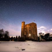
The old wooden trestle railway bridge under which the walk passes is part of a pair which are unique in England as the last surviving examples of their kind. The line closed in 1966 and the bridges were restored in 1995 in a joint project between Essex County Council and English Heritage, with National Lottery funding. The old Wickham Bishops station is now a private dwelling, situated between the trestle bridge viaduct and the section of old track which forms part of the walk. St. Peter’s Church was originally constructed for the Bishops of London, recorded in the Domesday Book as owning the village (hence its name). As the centre of the village migrated east, St. Peter’s was superseded as the centre of worship by St. Bartholomew’s, built in 1850. By the 1970s St. Peter’s had become redundant and was falling into disrepair, until it was adopted by the Friends of Friendless Churches charity in 1975 and stabilised, if not completely restored. There are plenty of woods in the area but most are privately owned. Shut Heath Wood, just east of the village on Tiptree Road (TL853133; CM83ED) is a nature reserve managed by Essex Wildlife Trust and open to the public. To explore more of the Blackwater valley, its confluence with the River Brain can be visited at Whetmead nature reserve in Witham (accessible via Blackwater Lane (TL828138; CM8 3LH) or its confluence with the Chelmer – made more complicated by the canal work – at Beeleigh Falls, probably best reached by walking the mile or so along the canal from Maldon.

The Walk (Note: this is a stile-free route).
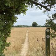
1. Skirt a metal gate and head down the track from the layby. Cross an old bridge over a disused railway line and turn left at a fingerpost. The path then drops onto the route of the old Witham to Maldon railway line, now managed as the Blackwater Rail Trail. Follow the pleasant, leafy trail for over a kilometre, at one point passing under a farm bridge, then turn left at a waymarker post where a tree-lined field-edge path winds off up the slope of the valley. Pass a pleasant private garden then cross the Langford Road and turn left, following a narrow field-edge path.
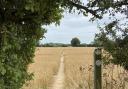
2. From the field access opposite a large, restored, black barn follow the grassy track north-east towards a wood. At the wood, skirt around to the right, eventually passing an old gate to enter a fenced section of path leading to a field. The path heads straight into the field to meet its edge on a bend opposite, with the hedgerow on your left. After 400 metres a metal gate opens into a lane.
3. Turn left then pass through a wooden kissing gate on the right, leading to a fenced path across pleasant parkland. At the next gate turn right, along the lane, then left at the junction onto Station Road. Pass Hill Place on the left and Hill Place Cottage on the right, then descend some footpath steps indicated by a concrete fingerpost on the right. The path heads down the valley slope, beside a rather unrural metal fence, then passes some paddocks.
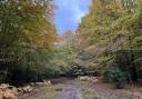
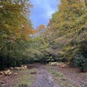
4. A wooden kissing gate leads out into Drumochter Farm; turn right and a metal kissing gates opens into a fenced path skirting horse pasture. A wooden kissing gate and footbridge then accesses Sparkey Wood, a lovely old coppice woodland which is home to several large colonies of wood ants. The track through the wood passes climbs uphill to reach Mope Lane.
5. Turn left, then at Thistle Hall turn left again onto the signposted footpath. At a wooden kissing gate the path turns right and passes anticlockwise through Mope Wood, over a footbridge and through another kissing gate. From here a very straight path, high-hedged on both sides, stretches rather surreally into the distance. It eventually opens out onto a golf course, continuing straight across it, towards a Giant Redwood tree in the distance.

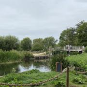
6. The Redwood is in the garden of the property across the road but our path follows the verge of the road for a few metres before heading back onto the golf course beside the River Blackwater (it may be easier and safer to follow the inside of the hedge rather than emerge onto the road). The path is now very easy to follow, along the riverbank. For a kilometre this also crosses the golf course, before passing over a sluice and then passing beside a willow plantation.
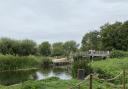
7. The riverside path narrows, so be careful, before another somewhat surreal sight emerges; the trestle bridge via which the disused railway once crossed the Blackwater here. Pass under the bridge (mind your head) and the path bends around the site of an old mill, crossing the river almost unnoticed meaning it suddenly appears on the left. At the road, turn left across another handsome old bridge, then carefully cross the road to access a path between white railings. Turn left and follow the path, past a metal gate, leading to St. Peter’s Church. From St. Peter’s head up the track, over the old railway bridge and back to the start.

COMPASS POINTS
Distance: 5.8 miles (9.3km).
Starting point: Layby on Langford Road, at the top of the track to St. Peter’s Church: grid reference TL827113; postcode CM8 3JD.
Access: Parking in the layby is limited. There is alternative parking at St. Bartholomew’s Church (TL837120; CM8 3LA) from where the walk may be accessed at point 5 via Mope Lane. The nearest bus stop is Snow’s Corner, served by the regular Witham to Maldon 90 service (‘Blackwater Link’).
Map: OS Explorer 183 Chelmsford & The Rodings.
Refreshment: There is a shop and a tea-room on Maypole Road in Wickham Bishops. The nearest traditional pubs are the Green Man at Little Braxted (TL849130; CM8 3LB) and the Prince of Wales at Great Totham (TL855112; CM9 8PX).