WALK: To the lighthouse
STANDFIRST: Enjoy a summer walk round the most southerly point of the Isle of Wight taking in a stunning stretch of coastline and wonderful sea views
WORDS & PHOTOS: Fiona Barltrop
Sometimes referred to as ‘England in miniature’, the Isle of Wight has a remarkably diverse landscape. Over half the Island is designated as a National Landscape (formerly an Area of Outstanding Natural Beauty) and there’s an excellent network of footpaths and bridleways, including a coastal path that encircles it and quite a number of named and waymarked trails.
The southernmost tip of the Island shouldn’t be missed. Surrounded by unspoilt countryside and situated near one of the most dramatic stretches of the Island’s coast, the attractive village of Niton makes an ideal base for walkers. This walk takes you along the coastal path westwards, then climbs to St Catherine’s Hill atop which stands St Catherine’s Oratory, known as the Pepperpot, a striking 14th century octagonal tower (resembling a stone rocket) which served as a lighthouse. Some earthworks are the only visible evidence of the former adjoining oratory. A new lighthouse was begun nearby in the 18th century – the remains at the base of the nearby mast – but being located so high, both were often mist-shrouded. St Catherine’s lighthouse, built at sea level, followed in the 19th century.
The walk continues north along the beautiful downland ridge of St Catherine’s Down to the Hoy monument, a 72ft high column built to commemorate the visit to Britain in 1814 of Tsar Alexander I of Russia. Thereafter it’s back to Niton, but for those with the time and energy an excellent additional loop heading down to St Catherine’s Point, where the lighthouse is situated, is much to be recommended.

THE WALK
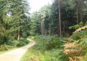
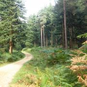
1. (SZ505767) With your back to the church turn right to the junction with the main road. Continue in the same direction, and after the last house turn left up the footpath which leads across fields to the Coast Path. Turn right along the cliff top path, St Catherine’s lighthouse soon visible below you, situated in the area called the Undercliff. This is the name for the narrow strip of landslipped terrain, lying between the sea and high cliffs, which stretches for some eight miles from Luccombe Bay in the east to Blackgang in the west. Once above Blackgang, ignoring the theme park below you, there’s a splendid view along the coast towards the distant chalk cliffs. Bear right to the car park.

2. (SZ491767) Cross the road, climb the steps and follow the path signed to St Catherine’s Oratory diagonally left up the fields, aiming to the left of the mast. According to local legend, St Catherine’s Oratory was built as penance by Walter de Godeton, Lord of Chale, who helped himself to wine from a shipwreck in Chale Bay that came from a French monastery. There are wonderful views from up here.

3. (SZ493772) Continue to the nearby fence, on the other side of which is the trig point. Keeping the fence on your right, turn left alongside it and head downhill along the ridge-top path. Pass a gate on the right and bear diagonally left to go through a gate (St Catherine’s Down National Trust sign here) and continue north along the delightful grassy ridge – carpeted with bluebells in spring – to the Hoy monument. The inscriptions on either side are somewhat incongruous. As well as the plaque commemorating the visit of the Tsar, there is another in honour of the British soldiers killed in the Crimean War.
4. (SZ496788) Retrace your steps to the gate by the NT sign, go through it and bear left to the gate passed before. Turn left through it and head across the grass, soon with the fence alongside on your left and a lovely view northwards across the downland towards the Hoy monument. Go through another gate onto a defined, enclosed track (muddy in winter) and continue to a junction of paths.
5. (SZ500775) Fork right down the bridleway (called Bury Lane) that leads to an access road that takes you back down to Niton. You can finish the walk at this point, but for the full route turn left along Church Street to the crossroads/High Street and turn right. Take the next footpath on the left, Puckwell Lane, and follow it to a multiple path junction. Follow the footpath signed to the Coastal Path.

6. (SZ513762) Turn right along the Coastal Path to the main road and right back up to Niton.
For an additional loop (3 miles/4.5km) around Catherine’s Point, before reaching the main road turn sharp left down an enclosed path between walls. Turn left at the A3055 and immediately right down St Catherine’s Road. Take the next left, Castlehaven Lane, continuing down the rough access road/bridleway which leads down to Castlehaven. Where it bends left, keep ahead along the footpath and very soon left at an NT sign. Bear left and continue down to the coast to reach it just west of Castlehaven (and a short closed section). Turn right along the coastal path to St Catherine’s Point and the lighthouse, skirting it on its landward side. Carry on to Watershoot Bay. Here turn back heading inland to NT owned Knowles Farm, and thence up the access road/St Catherine’s Road, left at the T-junction along Sandrock Road, bearing left along the A3055 (pavement) back into Niton.

COMPASS POINTS
Start/finish: Niton, considerate roadside parking, eg in front of church (SZ505767) or in car park behind library, preferably when library closed (SZ507767); another car park east of village at junction of Town End and Allotment Road; alternatively large Blackgang car park at pt 2 (SZ490767)
Map: OS Explorer OL29
Distance: 6¾ miles (10.8km) or shorter option (omitting pt 6 loop) 5 miles (8.2km)
Terrain: Grassy cliff top coastal path; downland paths and tracks; village roads
Time: 3 hours. Allow 1½ hours for St Catherine’s Point & lighthouse loop.
Refreshments: Joe’s Bar & restaurant/café at Niton Post Office (01983 730280)
Buddle Inn, Niton (01983 730243), White Lion, Niton (01983 719402); Castlehaven Beach Café (01983 730495)
Public transport: Wightlink car ferries between Lymington & Yarmouth and Portsmouth & Fishbourne; passenger catamaran from Portsmouth to Ryde, 0333 999 7333, wightlink.co.uk. Bus service 6 from Newport to Ventnor via Niton, Island Coaster from Ryde to Yarmouth via Niton (29 March to 28 Sept 2024), islandbuses.info.