Goathland. A picture perfect North York Moors village with sheep grazing on the greens. It was the main location of Aidensfield for the Heartbeat TV drama in the 90s and noughties. The garage has been maintained exactly as it appeared in the series and shops sell souvenirs from it. Situated on the North York Moors Railway, Goathland station featured as Hogsmeade station in Harry Potter and the Philosopher's Stone.
Whinstone Ridge. The little known ridge is better described as a 2km long v-shaped chasm created by quarrying for very hard roadstone from the early 19th century until just after the Second World War. Stone was transferred by tramway to Goathland station for crushing at a steam-powered plant and onward distribution. A footpath runs along the bottom.

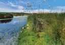
North York Moors viaduct. The footbridge that passes beneath the railway and above Eller Beck is an extraordinary spot. Look out for the memorial stone to a Stanley Porritt who drowned here in 1908. The railway is hidden for much of the walk, occasional ghostly whistles through the trees often providing the only evidence.
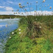
Thomason Foss. An idyllic, popular wild swimming spot with 20m-wide plunge pool accessed via an optional wooded diversion from the hamlet of Beck Hole.

Goathland incline. The counter-balance incline system was devised by George Stephenson in the mid-19th century to transport carriages up and down the 1 in 5 gradient on the Whitby and Pickering railway, then horse-drawn.
Mallyan Spout. A curtain of water and spray spurts down rocks deep in a ravine. All the more dramatic after heavy rain, the Spout measures 20m and is the highest waterfall in the North York Moors. No opportunity for swimming.

1. Turn left out of the car park and descend towards Goathland station. Cross the railway line and turn left and up signed to Goathland Moor (not Darnholme). Soon join broad track coming in from your right. Stay on it to cross the moor and reach the road.
2. Cross the road and continue ahead along grassy track to Whinstone Ridge. Descend into the dip and turn left to walk along then up and out of it. Turn left and follow what soon becomes a tarmac lane that returns you to the road.
3. Turn right onto road and, after 300m, fork left onto a track leading to Hawthorn Hill Farm. As you approach the farmhouse bear right and follow the path around the farm, keeping the wall on your left.

4. At the wall corner follow path through bracken to the left of the large sycamore in a walled enclosure. The descent gets much steeper as you near the railway viaduct with a footbridge under it. Just before the bridge turn right and follow the path to and past Lins Farm after which path becomes a track. Bear left at Hall Farm and descend along its access road. Turn sharp left to cross the rail bridge and pass through the hamlet of Beck Hole.
5. To divert to Thomason Foss follow the out and back signed footpath. Look for the fingerpost just before the river bridge beside the post box. Cross the river bridge and then, after the Birch Hall Inn, turn right through a gate and down a path leading to the route of the old railway line. Turn left onto it then almost immediately turn right signed to Mallyan Spout.
6. After viewing the waterfall retrace your steps for 130m then turn right up steps signed to Goathland. At the road turn left and follow road back into the village centre.
Accessing Thomason Foss
Looking at the map you may be tempted to try reaching Thomason Foss from the east, starting at a footbridge under the railway viaduct (see point 4), and thereby avoid the diversion from Beck Hole (see above). An unofficial path 30m to the west of the footbridge within open access land branches off left from the marked footpath down through the trees eventually reaching the Foss but it's narrow, steep and hazardous particularly in wet conditions.
COMPASS POINTS
Start/finish: Goathland, YO22 5LX, grid ref NZ 833 013.
Time/distance: 4 hours/10 km.
Accessibility: The final approach to Mallyan Spout involves scrambling over sometimes slippery boulders.
Maps: OS Landranger 94 Whitby & Eskdale, OS Explorer 27 North York Moors eastern area.
Parking: Two car parks in Goathland, both charging a flat rate of £4. No roadside parking.
Map link: bit.ly/GoathlandYL
EAT HERE

The Birch Hall Inn, Beck Hole. Vintage Yorkshire country pub. The 'bar' is a hole in the wall which links to the shop which sells snacks and drinks. Food served includes simple sandwiches, pork pies, scones and beer buttered cake. Open 11.30am to 7.30pm other than Tuesdays and Saturdays from May to Sept. Strictly cash only.

Goathland Tea Rooms. Occupying a former doctor's surgery and including a garden, the tea rooms serves soup of the day, jacket potatoes, quiches, salads, all day breakfasts and cream teas. Vegetarian, vegan, gluten-free, nut-free and and dairy-free options available. goathlandtearooms.co.uk.